|
Despite accurate research and constant updating of the contents, errors may occur. We take no responsibility for the accuracy and completeness of all information.
For your safety, please ask the organizer for further information.
|
 |
|
|
Weather forecast
|
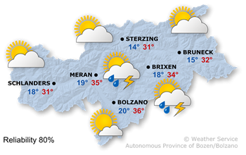
A high-pressure system, combined with subtropical air masses, is set to bring another hot summer's day.
|
It will be very sunny this morning, with any remaining morning clouds clearing quickly. In the afternoon some isolated thunderstorms.
Maximum temperatures are rising slightly again, reaching 28° in the upper Puster Valley and up to 36° in the lowlands.
|
Conditions will be good in the morning, but watch out for localised thunderstorms in the afternoon and evening.
|
Tuesday

Temp. max: 36°C
Temp. min: 18°C
|
Wednesday
Temp. max: 37°C
Temp. min: 18°C
|
Thursday

Temp. max: 36°C
Temp. min: 18°C
|
|
On Tuesday morning, there will be bright sunshine; in the afternoon, isolated thunderstorms will develop again, but it will mostly remain dry.
Wednesday will also bring plenty of sunshine in the morning, but even afterwards, only isolated thunderstorms are expected.
On Thursday, the sunshine will continue, though thunderstorms will become more frequent in the afternoon.
Friday will bring a mix of sunshine, clouds and a few thunderstorms.
|
|
|
|
Source: Hydrographic Office of the Autonomous Province of Bolzano
|
|
|
|
|
|
|
|
|

Webcam in Marlegno |
|
|
|
|
|
|
|


